Bill and the Allenheads Geo Tour


Images: Bill Aitchinson ACA


The Allenheads Geo Trail: British Stoats, Canadian Geese and American Squirrels.
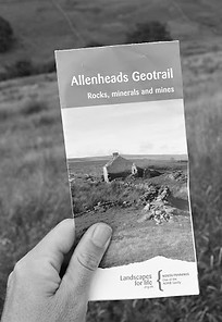
I am now in Allenheads, Northumberland, the highest village in England, perched up towards the Scottish border. It is in the North Pennines which is, among other things, a European Geopark, that's to say an area with a particularly interesting geological landscape. There is a geotrail that introduces visitors to the area, and it is available as a free brochure and also viewable online.
The centre of the village is quite definitely the pub and it from here that the trail departs. From my brochure I learnt that a stone's throw away from the pub is the washing floor where lead ore was once processed, when the village was the centre of a thriving network of lead mines. This is now a forlorn space with the village's centre of gravity pulled 100 meters over to the Allenheads Inn, as the village's economy has shifted away from industry and nominally towards tourism.
I had already taken some walks around the area but I would not have noticed that there was a path that lay ahead of me if I were not on this trail. The brochure was useful then, as it revealed more ways in and out of the village than I was previously aware of. This is all good information to have as I'll be making a performance here next year and these entrances and exits are likely to figure highly. The village can be imagined as a stage equipped not only with windows and doors, but also with trap doors, curtains that may be parted and wires that pull the actors high into the skies, otherwise known as the helicopter that deposits VIPs here for the the grouse shoot.
There were a great many abandoned buildings that I came across, which together, said much about the fate of the countryside here. Depopulation has occurred on a large scale and the area has not yet become desirable enough for these more remote buildings to become in any way desirable. With some of them it feels like a matter of time before someone puts them right again and turns them to good purpose but with others, lost far out in the fields where no roads pass close by, they look set to tumble into the ground.
I came across this little fellow popping up from behind a rock. Is it a stoat or a weasel?
The path became broken and indistinct, the ground damp and muddy underfoot. I thought I had lost my way but it was simply a matter of the directions being sparse and the path rarely used. It is always a dilemma when describing routes to know how much information to give. A little bit of difficulty can be a pleasure, as uncertainty is rewarded with the joy of finding the correct path. Too much information denies this and can turn the experience into being all about the directions and not the landscape. The problem is, we are all a little different in how much we prefer difficulty over ease, and how well we can follow directions. Apart from this one stretch, the rest of the route was pretty simple and the level of information was about right for me.
Then the animals got bigger. Not getting out into the countryside so often these days, I was unsure how friendly the cows and bullocks were likely to be. I inched my way forwards and he turned out to be largely indifferent to my presence, much to my relief. I quickly made my way over the style only to enter another field of bullocks who were similarly absorbed in their grass.
This stone building turned out not to be as empty as it appeared to be on the outside. As I passed, a family of sheep came out to see who the visitor was. It seems these structures have tenants after all.
Flying above me were birds that I can only guess were Canada geese, though if you have a better shot, do leave a comment. Actually, when it comes to shots, when I returned to the Allenheads Inn at the end of the walk, I met some of the men working on the grouse shoot who had just finished work. They told me about a Canadian marksman who had recently visited, whose shot was so bad, it was embarrassing. As the shoot is now extremely expensive, it has become a rich man's game, and not all rich men (and it mostly is men) have the time to balance making their money with practising their shooting.
I stopped at number 10 on my map looking for the great limestone and found instead a sheep exploring the water's edge. The walk was, in fact, full of moments like this that didn't fit in with the brochure, but were nonetheless enjoyable as moments in themselves and which gave the tour is true flavour. This geotrail is one that gives you time to think in a quiet place where you will probably not see a single person.
The geotrail also highlights a number of chapels that the miners, many of them devout Methodists, used to use for worship. What puzzled me about this one, which is now a private home, is that it was built in 1900, after the mines had all closed. Poor timing.


